From England straight to Louisiana is quite a leap
You’re not kidding. Arriving from the UK into Sydney airport - the heat was unbelievable, but when I was in Melbourne, there was a question of ‘wait? is this weather … shit?’
but when I was in Melbourne, there was a question of ‘wait? is this weather … shit?’
Ah you just gotta wait 3 minutes and it’ll change.
Melbourne is a tropical London.
“A Tropical London” is a sexual maneuver that is, quite ironically, banned in Victoria.
The Australian state containing Melbourne, that is. You’re allowed to attempt it with consenting women named Victoria elsewhere.
Can you describe this maneuver? The woman’s name is irrelevant in this scenario
Can you describe this maneuver
Unfortunately, doing so is banned in Denmark.
It’s also a song by Rancid - https://youtu.be/R6ZZn5_1fGk?si=grmU8VR5n9Q6yWAt
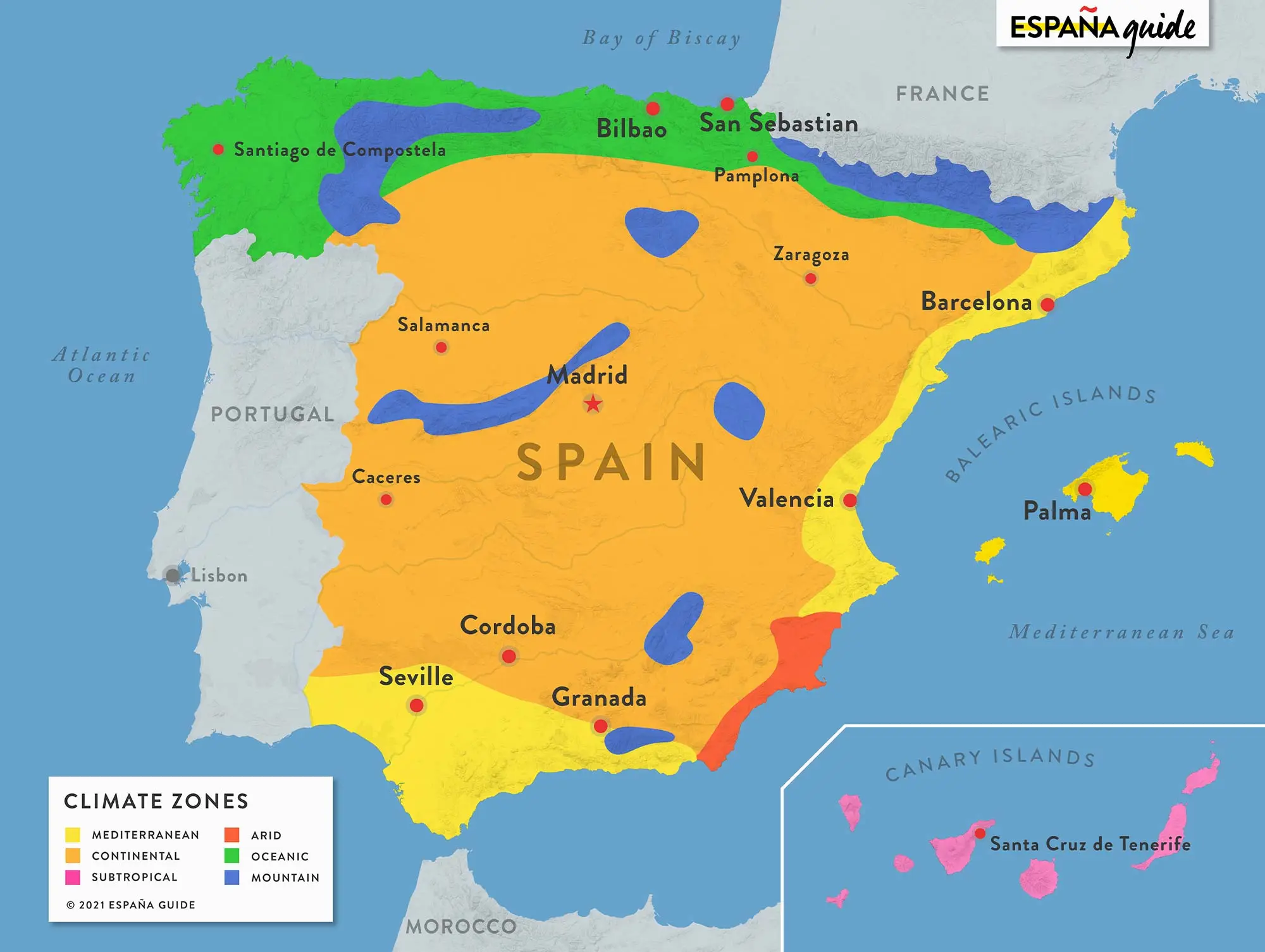
Not necessarily. look at what Spain has in an area a bit smaller than Texas.

Yeah, exactly, Melbourne weather is just your average UK.
Ok, sure, London gets 1.5k sunshine hours per year, Manchester 1.3k, Naples 2.3k, Rome 2.5k, and then Melbourne is also 2.3k. But those are minor differences of some 60-70% percent.
So, you, know, basically, Italy also has UK weather.
Have you been to Rome in summer? It’s lovely. A bit of rain now and then, a cool breeze in the evening. Some clouds during the day to help you not to get sunburned.
Melbourne weather
is justas shitty as your average UK.
“Southern Nevada” and “Los Angles” are very different.
Thank you! Clearly the map maker has never been to Las Vegas and Los Angeles in the summer. VASTLY different. There’s a reason LA is the second biggest city in America and the weather is a huge part of it. Surfing weather vs Death Valley lite.
And I doubt that they have been to Spain. Central Spain is -5º in the winter to 40º+ in the summer, and dry AF. Central Spain is a plateau, elevation 700m, so it has no buffering from the coast. I very much doubt you’d have that in a coastal region.
Removed by mod
I think they just spelled Vegas wrong. That region is barren desert.
Removed by mod
Los Angeles is not a desert. Los Angeles has an enormous agriculture industry surrounding the area - farms don’t work well in a desert. LA is a type of savanna, specifically an oak savanna, compared to the high, dry desert of southern Nevada. It isn’t a minor climate shift - they are two radically different environments. The only thing that they share in common is getting hot in the summer.
There is even a “Southern California” zone 🤔
Removed by mod
finland ☝️
It’s the same weather but suddenly everyone stays 3m away from each other all the time
The ACT does get a bit cold in winter, but I feel like it’s closer to England than Finland (if England was drier and actually got hot in summer anyway). We are after all talking minimums of -5 or -6 for the coldest days in winter and snow normally only settling on the tops of the nearby mountain range (and temporarily at that).
Would have been far better to get the name of the climate instead of some american region, or an ultra broad category like “north india”, which has the himalyas, plains, jungle, and much in between

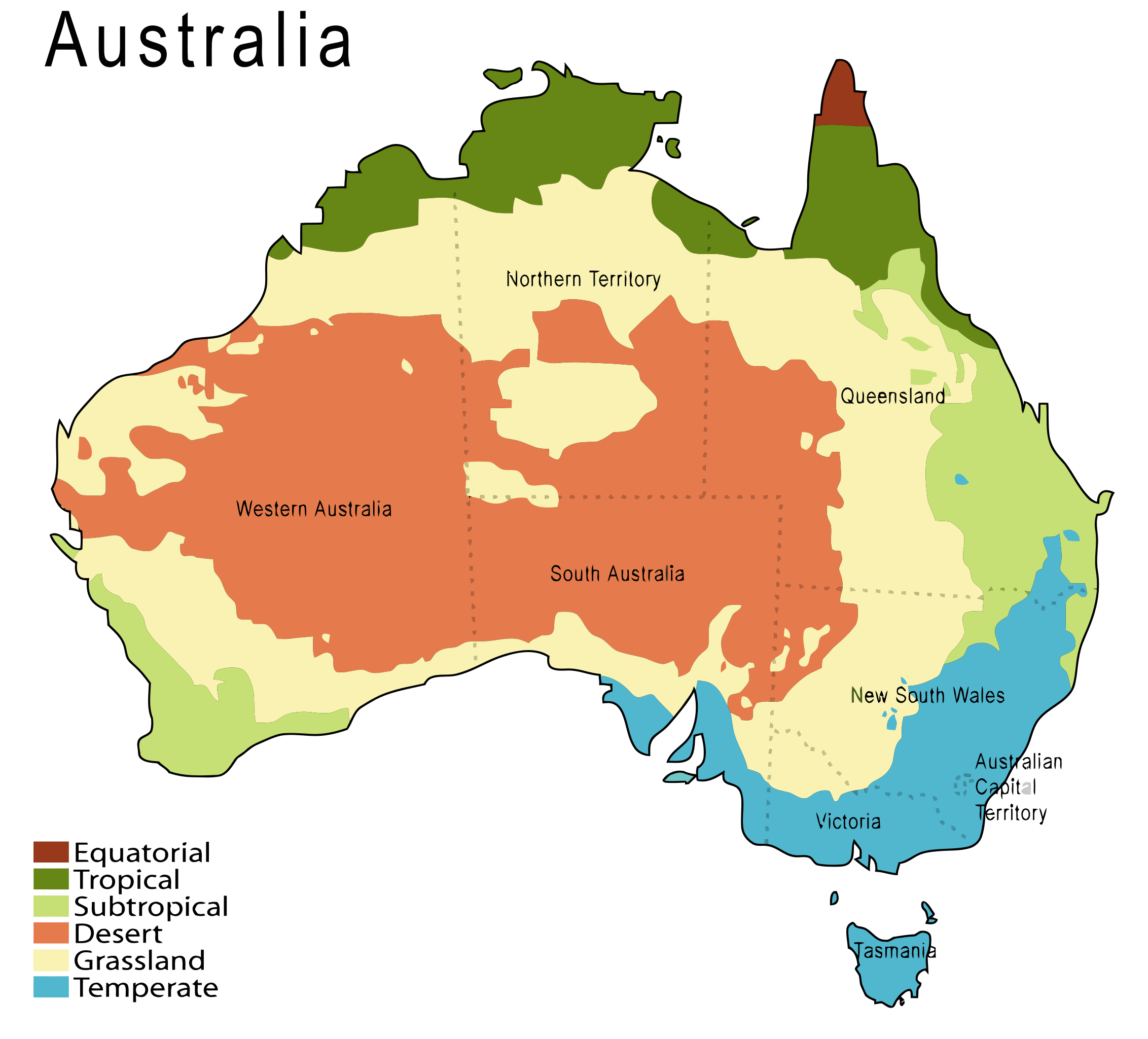
You’d be wanting this shitty map. Congrats now you know Victoria is temperate, what it doesn’t tell you is that we’re often wet and miserable like in England or that you’ll get snow in Tassie.
I much rather OPs map.
South Texas is too vague. We talking coastal humidity, searing temperatures, flooding rains, drought, or all of the above?
Same as alaska, It ranges from full on permafrost, to temperate climate.
As an American who understands other countries climates, I understood and appreciated this map perfectly fine, and because I understand the general climates of Australia I can understand what is meant by North India…and it’s not the himilayas
As someone who lived a large part of my life in australia, so can I. But the point is not if I or you can understand it, but if the general audience can, if it is portrayed in both an accurate and rigorous way.
Unfortunately, it isn’t.
Also elevations would be helpful to understand the map.
Is this accurate? How can it be so varied even on similar latitudes?
There’s this big cold place down south that sends massively cold air up to the bottom of Australia. Whereas the top is literally situated in the tropics.
Add to that we’re surrounded by multiple current and airstreams hitting each side of the continent. And the Mountain ranges along the east coast make the interior drier and hotter.
Oh and Ausstralia is big. If Europe can go from snow up north to beach holidays in the Mediterranean, why wouldn’t we also be as varied and more.
I’d imagine elevation and proximity to the coast affect things a bit. I’ve seen a similar one for the US that was also quite varied.
Check out the vegetation zones of Washington State. Oceans and mountain ranges have a massive effect on climate zones.

Finally, a map I can understand.
After living and working in that red-zone… totally nailed the caption. Beautiful and hot.
Removed by mod
Understood, it was intense but rewarding.
Downright idiotic to use “Northern India” as a known climate. During COVID the air-pollution cleared up enough to photograph the foothills of the Himalayas from New Delhi.
Can you imagine HOW much Indians have screwed up the entire climate of India ?
It is not even funny the deaths caused due to man-made pollution in India.
And Indians are the majority causing the man-made pollution not “foreign” entities.
Removed by mod
How would this help anyone? Like, noone just knows what those climates feel like, at all.
Removed by mod
No ‘South Wales’? For shame
Removed by mod


