I have a clear globe that i would like to project to a flat map. Any common projection should work, since computer programs exist for converting map projections. Where should i start?
A couple of details: First, my “globe” is an empty plastic Christmas tree ornament, so it can be hung from a string at one end but it doesn’t have a stand like a normal globe does.
Second, this is a worldbuilding thing. My globe does not represent any real planet or similar body, which is why i need to make a new map from the globe instead of finding an existing one.
EDIT: To be clear, i know about projections already. I’m not worried about picking a projection. What i’m asking about is the process is for taking a physical globe and projecting that globe’s surface onto a flat rectangle. I don’t know how to turn an imaginary cylinder or cone sitting on my globe into a tangible physical or digital map. I don’t have the means to cut up and unfold my globe until it’s flat. What is the actual process for making a map from a globe, for any projection? I know this isn’t how maps are traditionally made, but surely there must be a good way to do this.
I’m not a cartographer, but the way I’d tackle this is to drill a small hole in the globe and spray paint in through it, so that the inner surface is opaque white. Then I would put together a cheap turntable-style 3D scanner using an off-the-shelf camera (there are open source designs available for this that you can buy as a kit or print using a 3D printer, then assemble following step-by-step instructions). Then, after scanning the globe and obtaining a textured 3D model of it, it should be relatively easy to convert the globe’s texture from a spherical shape to a standard map projection using software. I don’t know what software that would be offhand, but I’m sure it exists.
The process of actually projecting the contours on the globe onto a flat (cylindrical) map is by either putting a strong light source inside the globe and place the paper cylinder around it. This projects the contours onto the cylinder. The contours then need to be traced onto the cylinder using a pen. The other option, e.g. if the globe isn’t translucent, is to paint a longitude/latitude grid onto it and start with an empty rectangular map with the same grid structure. Then, for every trapezoid on the globe, its content needs to be transferred to
athe coresponding rectangle on the map.I’m currently working on that second option, since it seems easier than trying to trace shapes on a paper cylinder around my globe. Thanks.
I hope it works out.
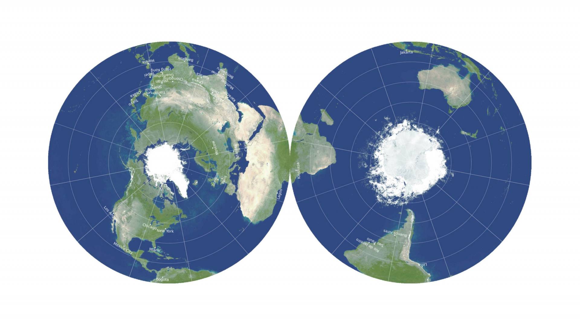
Objectively, the Gott, Goldberg, and Vanderbel projection method distorts the least.
For some definition of “least”.
Using their own scoring system for distortion, a globe would be a 0, a Mercator projection would be 8.296, Winkel Tripel is a 4.563, and their projection would be a 0.881.
That’s interesting, though their own map benefits from their definition of B (the number of boundary cuts an arbitrary line segment needs to cross), because this metric does not take into account how far away the elements on the map are from each other. E.g. the cuts going from northern to southern Africa count as much as a “distortion” as the ones separating Indonesia and South America.
Ultimately, “objective” best depends on the metric you choose and that is a subjective decision.
Agreed, this map isn’t particularly usable to the average person.
Well, gee, thanks for the rabbit hole!
Unless you’re Icelandic
Mercator always a.crowd favorite.
The AuthaGraph is considered the most accurate flat map from a globe.
I guess you want a projection that distorts your oceans whilst keeping your land masses as proportional as possible, right?
Very good point. It would depend entirely on the locations of the land masses on OP’s globe.
Better than Butterfly? Better than Dymaxion??